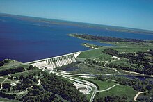
Lake Whitney (Texas)
Reservoir in Texas, United StatesLake Whitney is a flood control reservoir on the main stem of the Brazos River in Texas. It is located on River Mile Marker 442 and controls drainage for 17,656 square miles (45,730 km2) of Texas and parts of New Mexico. The reservoir encompasses a surface area of more than 23,500 acres and 225 miles (362 km) of shoreline. The area consists of rolling, tallgrass prairies; cedar trees; hardwood timber; and 100 ft (30 m) bluffs and rock points. Lake Whitney is also part of the Texas Lakes Trail Region of North Texas.
Read article
Top Questions
AI generatedMore questions


